
search
Barcelona airport bus map
Map of barcelona airport bus. Barcelona airport bus map (Catalonia Spain) to print. Barcelona airport bus map (Catalonia Spain) to download. Although this option is slower, city buses are the most economical way to get from airport to the center of Barcelona (as its shown in barcelona airport bus map). The Barcelona bus line in service during the day is the 46 and it is the N17 to make the trip at night. On the way from Plaza de Catalunya to the airport, the bus makes many stops and can take almost an hour to reach its terminus. The journey of Barcelona bus time is between 30 and 50 minutes and the frequency is about 20 minutes.
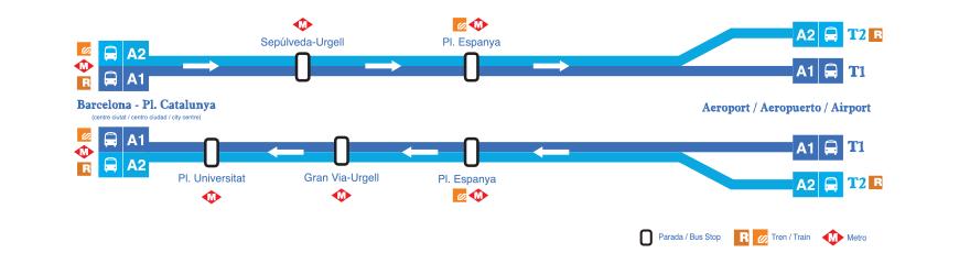
A daily bus that leaves on average every five or ten minutes from airport to Barcelona city. The journey takes about 35 minutes and costs €5.90 (€10.20 for a round trip). You order the tickets simply via this website. There are two different Aerobus lines: Aerobus A1: between Barcelona and the new BCN Airport Terminal T1. Aerobus A2: between Barcelona and BCN Airport Terminal 2. Both Aerobus A1 and A2 enter by the Plaça d'Espanya - Gran Vía/Urgell - Plaça Universitat Barcelona road and have Plaça de Catalunya as their final destination. Back at BCN Airport you can get off at Plaça de Catalunya or Plaça d'Espanya.