
search
Aerobus barcelona map
Barcelona aerobus stops map. Aerobus barcelona map (Catalonia Spain) to print. Aerobus barcelona map (Catalonia Spain) to download. Aerobus is the official shuttle bus service that connects the airport BCN-El Prat y and the centre of Barcelona every 5 minutes, every day of the year, in approximately 35 minutes as its shown in aerobus barcelona map. Passengers are able to travel between any of the two airport terminals (T1 or T2) and the centre of Barcelona (Pl. Catalunya) in only three stops in a fast, comfortable and economical way. Along the aerobus route its stops at the most important points of Barcelona: Pl. Catalunya, Sepúlveda-Urgell, Pl. Espanya, Gran Vía-Urgell, and Pl. Universitat.
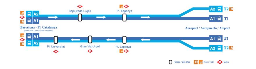
Barcelona aerobus is a shuttle bus that takes you from El Prat Airport to Barcelona city centre in 35 minutes. One departure every 5 minutes. Easy to take both to and from, Barcelona aerobus is the most commonly used means of transport for travellers arriving by air. From the airport terminal T1 or T2, the shuttle takes you to Pl. Espanya / Gran Via Urgell / Pl. Universitat and finally Pl. Catalunya. Four strategic districts of Barcelona that will allow you to easily reach your accommodation during your stay in the Catalan capital (as its mentioned in aerobus barcelona map).
If you are arriving at El Prat (this is the ONLY airport in Barcelona some budget carriers do also fly to nearby Reus and Girona airports), you can catch the Barcelona aerobus at either Terminal 1 (T1) or Terminal 2 (T2) as its shown in aerobus barcelona map. If you land at Terminal 2 you will be boarding the A2 Aerobus. It takes the same route at the A1, but just with a different starting point.